Glasgow Central station
| Glasgow Central | |
|---|---|
 |
|
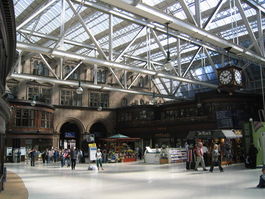
| Inside Glasgow Central, looking north east across the main concourse | |
| Location | |
| Place | Glasgow |
| Local authority | Glasgow City Council |
| Operations | |
| Station code | GLC |
| Managed by | Network Rail |
| Platforms in use | 17 (including 2 on lower level) |
| Live arrivals/departures and station information from National Rail |
|
| Annual rail passenger usage | |
| 2002/03 * | |
| 2004/05 * | |
| 2005/06 * | |
| 2006/07 * | |
| 2007/08 * | |
| 2008/09 * | |
| Passenger Transport Executive | |
| PTE | SPT |
| History | |
| 1 August 1879 | High Level Station opened[1] |
| 10 August 1896 | Low Level Station opened[1] |
| 1901–1905 | High Level Station rebuilt |
| 1960 | Re-signalling |
| 5 October 1964 | Closure of Low Level Station[1] |
| May 1974 | Start of "Electric Scot" services to London Euston |
| 5 November 1979 | Reopening of Low Level Station as part of Argyle Line[1] |
| 1984–1986 | Refurbished |
| 1998–2003 | Refurbished |
| National Rail - UK railway stations | |
| A B C D E F G H I J K L M N O P Q R S T U V W X Y Z | |
| * Annual passenger usage based on sales of tickets in stated financial year(s) which end or originate at Glasgow Central from Office of Rail Regulation statistics. | |
| Glasgow Central & St Enoch approaches | |||||||||||||||||||||||||||||||||||||||||||||||||||||||||||||||||||||||||||||||||||||||||||||||||||||||||||||||||||||||||||||||||||||||||||||||||||||||||||||||||||||||||||||||||||||||||||||||||||||||||||||||||||||||||||||||||||||||
|---|---|---|---|---|---|---|---|---|---|---|---|---|---|---|---|---|---|---|---|---|---|---|---|---|---|---|---|---|---|---|---|---|---|---|---|---|---|---|---|---|---|---|---|---|---|---|---|---|---|---|---|---|---|---|---|---|---|---|---|---|---|---|---|---|---|---|---|---|---|---|---|---|---|---|---|---|---|---|---|---|---|---|---|---|---|---|---|---|---|---|---|---|---|---|---|---|---|---|---|---|---|---|---|---|---|---|---|---|---|---|---|---|---|---|---|---|---|---|---|---|---|---|---|---|---|---|---|---|---|---|---|---|---|---|---|---|---|---|---|---|---|---|---|---|---|---|---|---|---|---|---|---|---|---|---|---|---|---|---|---|---|---|---|---|---|---|---|---|---|---|---|---|---|---|---|---|---|---|---|---|---|---|---|---|---|---|---|---|---|---|---|---|---|---|---|---|---|---|---|---|---|---|---|---|---|---|---|---|---|---|---|---|---|---|---|---|---|---|---|---|---|---|---|---|---|---|---|---|---|---|---|
|
|||||||||||||||||||||||||||||||||||||||||||||||||||||||||||||||||||||||||||||||||||||||||||||||||||||||||||||||||||||||||||||||||||||||||||||||||||||||||||||||||||||||||||||||||||||||||||||||||||||||||||||||||||||||||||||||||||||||
Glasgow Central is the larger of the two present main-line railway terminals in Glasgow, Scotland, and is managed by Network Rail. It is the northern terminus of the West Coast Main Line, and was opened by the Caledonian Railway on 31 July 1879.[2]
The station serves all of the Greater Glasgow conurbation's southern towns and suburbs, and the Ayrshire and Clyde coasts, and is the terminus for all inter-city services between Glasgow and destinations in England.
The Office of Rail Regulation, which estimates usage through analysing ticket sales, ranks Glasgow Central as the busiest station in the United Kingdom outside London with 27.5 million annual entries and exits.[3] Network Rail, which manages the station and measures usage through counting footfall, ranks Glasgow Central as the second busiest outside London after Birmingham New Street, with 38 million annual visitors, 80% of whom are passengers.[4]
Contents |
Original station
The original station, opened on 1 August 1879 on the north bank of the River Clyde, had eight platforms and was linked to Bridge Street station by a railway bridge over Argyle Street and a four-track railway bridge, built by Sir William Arrol, which crossed the Clyde to the south.[2]
The station was soon congested. In 1890, a temporary solution of widening the bridge over Argyle Street and inserting a ninth platform on Argyle Street bridge was completed.[2][5] It was also initially intended to increase Bridge Street station to eight through lines and to increase Central station to 15 platforms.[2]
Low-level station
The low-level platforms were originally a separate station, and were added to serve the underground Glasgow Central Railway, authorised on 10 August 1888 and opened on 10 August 1896.[2][6] The Glasgow Central Railway was taken over by the Caledonian Railway in 1890.[2][6] Services ran from Maryhill Central and from the Lanarkshire and Dunbartonshire Railway in the west through to Rutherglen and via Tollcross through to Carmyle, Newton, and other Caledonian Railway destinations to the east of Glasgow.
The 1901–1905 station rebuild
By 1900 the station was again found to be too small, passenger numbers per annum on the high-level station having increased by 5.156 million since the first extension was completed in 1890.[5] Passenger usage per annum in 1899 was 16.841 million on the high-level station and 6.416 million on the low-level station, a total of 23.257 million.[5] The station is on two levels: the High-Level station at the same level as Gordon Street, which bridges over Argyle Street, and the underground Low-Level station.
Between 1901 and 1905 the original station was rebuilt.[2] The station was extended over the top of Argyle Street, and thirteen platforms were built.[2] An additional eight-track bridge was built over the Clyde,[2] and the original bridge was raised by 30 inches (0.75 m).[7] Bridge Street station was then closed.[2]
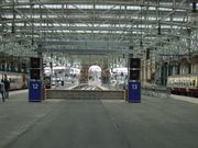
The High-Level station now has 13 platforms, covered by a large steel ridge/furrow roof. These platforms are numbered 1–11 and 14–15. The former Platform 12 was created during the 1901–1905 rebuild but was not originally for passenger use: it was known as the Fish, Fruit and Milk platform.
Central Station has a spacious concourse containing shops, catering outlets, ticket offices and a travel centre. It is fronted by the Central Hotel on Gordon Street, designed by Robert Rowand Anderson. The station building also houses a long line of shops and bars down the Union Street side. The undercroft of the station is not open to the general public: it houses private car-parking and utility functions for both the station itself and the adjoining Central Hotel.
The station's famous architectural features are the large glass-walled bridge that takes the station building over Argyle Street, nicknamed as the "Heilanman's Umbrella" or Hellamans Umbrella. by locals[2] because it was used as a gathering place for visiting Highlanders;[8] and the former ticket offices / platform and train-destination information building. This was a large oval building, with the booking office on the ground floor and the train information display for passengers on large printed cloth destination boards placed behind large windows on the first floor by a team of two men. Underneath the "Umbrella" is a bustling array of shops and bars, as well as the "Arches" nightclub, theatre, gallery and restaurant complex.
The Central Hotel
_Central_Station,_Glasgow.jpg)
Central Station is fronted by the Central Hotel on Gordon Street. Adjoining onto the station concourse, it was one of Glasgow's most prestigious hotels in its heyday. Famous guests included Frank Sinatra and Winston Churchill.
It was originally designed by Robert Rowand Anderson, in 'Queen Anne style'; he also furnished the public rooms.[9] The hotel was completed in 1883, but was extended along with the station in 1901–1906.[9] The hotel extension was designed by James Miller and it opened on 15 April 1907.[9]
The world's first long-distance television pictures were transmitted to the Central Hotel in the station, on 24 May 1927 by John Logie Baird.[10] The hotel was sold by British Rail in the 1980s, and passed through the hands of various private operators until its most recent owner, the Real Hotel Group, went into administration in February 2009, and the hotel subsequently closed amid concerns of asbestos contamination and structural deterioration.
In June 2009, it was revealed that a new company had acquired the hotel building, and plans to refurbish and rebrand it as the Glasgow Grand Central Hotel were revealed. It is expected to re-open in September 2010.[11]
Signalling
The original 1889 signal box was replaced with an electro-pneumatic power-operated box based on the Westinghouse system.[12] Work started in October 1907 and it opened on 5 April 1908.[12] It was built directly over the River Clyde, sitting suspended between the two river bridges, well above the level of the tracks.[12] Inside was a frame of 374 miniature levers, making it the longest power frame ever built in Great Britain.[13]
Glasgow Central Signalling Centre, located in the "vee" of Bridge Street Junction, opened on 2 January 1961. It replaced signal boxes at Central Station, Bridge Street Junction, Eglinton Street Junction and Eglinton Street Station.[13] When initially opened it was capable of handling 1,000 routes.[13]
The new signalling centre was needed for three reasons:
- The 1907 power signal box was worn out;
- The original 1879 bridge over the River Clyde was coming to the end of its useful life, and it was more effective to use the newer (1904) bridge to handle all the traffic, with the lines signalled bi-directionally;
- Electrification of the Cathcart Circle Lines, and subsequently the Gourock and Wemyss Bay services and the West Coast Main Line.[13]
Glasgow Central Signalling Centre closed on 27 December 2008, when its area of control was transferred to the new West of Scotland Signalling Centre (WSSC) at Cowlairs. The NX panel is to be preserved. The station is currently signalled by two Westinghouse Westlock Interlockings which are controlled via a GE MCS control system.
Railway electrification
Overhead power lines began to appear on the high-level platforms by the mid-1960s. Firstly came 6.25 kV AC Overhead power lines from the Cathcart Circle Line electrification scheme, which started on 29 May 1962.[14][15] During this period, the old 1879 bridge over the River Clyde was removed and the railway lines were rearranged.[13]
This was followed by the 25 kV AC overhead-power-lines electrification of the Glasgow and Paisley Joint Railway and the Inverclyde Line to Gourock and Wemyss Bay, completed in 1967;[14] and the WCML northern electrification scheme in 1974. Part of the Cathcart Circle was upgraded to 25 kV AC supply in 1974, to provide a diversionary route;[15] the whole of the Cathcart Circle route was later upgraded to that supply.[15]
Plans exist to electrify other routes, such as the Whifflet Line, as part of a scheme to improve rail services in Scotland.
Late-20th-century developments
Low-level station
Closure
Services through the Low-Level station were withdrawn on 3 October 1964, said to be due to competition with the tram.[6] However, the trams had been withdrawn by 1962, so this may be a contradiction of the "Beeching Axe".
Re-opening
In 1979 part of the low-level line was electrified and the Low-Level station was re-opened as the Argyle Line of the Glasgow suburban railway network. It consists of a single island platform, numbered as platforms 16 & 17.
Initially services were provided by Class 303 and Class 314 units. The latter were built specifically for this service. Following the withdrawal of the Class 303 units, the service is, as of 2007[update], provided by Class 318 and Class 334 "Juniper" units.
Class 320 units were intended to be used on the route, but due to the position of the driver's monitors for checking doors, this proved impossible. Therefore, these units are restricted to the North Clyde Line. However, from September 2010 the Class 320s will be cascaded on to the Argyle line to replace the Class 334 sets, which are moving to the North Clyde route to operate on the new Airdrie to Bathgate line.
- Further details of services can be found in the Argyle Line article.
Flooding of the Low-Level line
Over the Christmas festive period of 1994, on 11 December, torrential rain caused the River Kelvin to burst its banks at the closed Kelvinbridge station, with the water making its way through the disused tunnels to Exhibition Centre and the Low-Level station,[16] which was completely submerged by the resultant flash flood. It was closed for many months while repairs were made.
In August 2002, torrential rain flooded out the low-level stations from Dalmarnock through to Exhibition Centre for a number of weeks. Most services were routed to the High-Level platforms, or to Queen Street station. Incidentally, the 2002 Glasgow floods had a number of other effects, causing a cryptospiridium outbreak in Glasgow's water supply.
1980s redevelopment
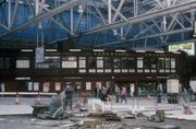
The high-level station's facilities were substantially redeveloped in the mid-1980s. The old ticket office / train information building was replaced in 1985 by an all-new Travel Centre adjacent to the Gordon Street entrance. By 1986 a large electro-mechanical destination board at the end of the platforms, with a smaller repeater board at the western side of the concourse, had replaced the former manually operated train-information boards. The old booking office / train information building was retained and redeveloped into shops, eateries and an upstairs bar/restaurant, and the station was re-floored in marble.
1998–2005 refurbishment

In 1998, a five-year renovation programme was initiated by Railtrack, which saw the station completely re-roofed and internally refurbished by Bovis Lend Lease.[17] The 1980s vintage mechanical destination boards were replaced with modern LED-style information signage. The final improvement, the upgrading of the upstairs restaurant area, was completed in 2005.
21st century developments
2009/10 expansion
In order to accommodate the cancelled Glasgow Airport Rail Link plans, an extended Platform 12 and a new Platform 13 were created by demolishing the former platform-level car park and passenger drop-off area.[18][19] Despite the cancellation of the airport link, these platform works went ahead. There are no plans to replace indoor parking or passenger drop-off within Central station. The existing multi-storey parking facility on Oswald Street and on-street parking surrounding Central station remain, with passenger drop-off having moved to surrounding streets.[20]
Barriers
Automatic ticket barriers are planned to be installed at Glasgow Central and three other city-centre stations in 2011 as part of a crackdown on fare-dodging to increase ticket revenue. This follows barriers being erected at Queen Street Station in 2004 ending ScotRail's "open stations" policy, under which staffed barriers had been scrapped during the 1980s to encourage more passengers; tickets were checked on trains instead. Currently, ScotRail is finalising negotiations with Network Rail over the project.[21]
Train operating companies
Five train-operating companies operate trains to and from this station:
- First ScotRail / SPT – Passenger services within Scotland, and sleepers to London Euston.
- Virgin West Coast – to London Euston andBirmingham New Street.
- East Coast – to Edinburgh, Newcastle and London King's Cross
- First Transpennine Express – to Manchester Piccadilly railway station and Manchester Airport railway station.
- CrossCountry – Cross-country routes via Edinburgh and the East Coast Main Line.[22]
A taxi rank is to the north of the station, while buses operate from the adjacent streets. St Enoch and Buchanan Street Subway stations are within a few minutes' walk of the station.
SPT operates a bus service to Glasgow Queen Street and the Buchanan bus station; this bus is numbered 398.
Future schemes
Renaissance Trains has proposed a twice-daily service from Glasgow Central to Liverpool Lime Street and Nottingham, with weekend trains running instead to Blackpool. As of 2009, the company is attempting to negotiate train paths with Network Rail.[23]
Services
| Preceding station | Following station | |||
|---|---|---|---|---|
| Motherwell | CrossCountry Cross Country Network |
Terminus | ||
| Motherwell or Carlisle |
Virgin Trains West Coast Main Line |
Terminus | ||
| Motherwell | East Coast East Coast Main Line |
Terminus | ||
| Lockerbie | TransPennine Express (TransPennine North West) |
Terminus | ||
| Motherwell | First ScotRail Lowland Caledonian Sleeper |
Terminus | ||
| Argyle Street | First ScotRail Argyle Line |
Anderston | ||
| Paisley Gilmour Street | First ScotRail Ayrshire Coast Line |
Terminus | ||
| Cardonald | First ScotRail Inverclyde Line |
Terminus | ||
| Pollokshields East or Pollokshields West |
First ScotRail Cathcart Circle Line |
Terminus | ||
| Dumbreck | First ScotRail Paisley Canal Line |
Terminus | ||
| Cambuslang | First ScotRail Shotts Line |
Terminus | ||
| Motherwell | First ScotRail North Berwick Line |
Terminus | ||
| Crossmyloof | First ScotRail Glasgow South Western Line |
Terminus | ||
| Carmyle | First ScotRail Whifflet Line |
Terminus | ||
| Historical railways | ||||
| Glasgow Cross Line open; station closed |
Caledonian Railway Glasgow Central Railway |
Anderston Line open; station open |
||
| Eglinton Street Line open; station closed |
Caledonian Railway Cathcart District Railway |
Terminus | ||
| Eglinton Street Line open; station closed |
Caledonian Railway Polloc and Govan Railway |
Terminus | ||
| Bridge Street Line open; station closed |
Caledonian and Glasgow & South Western Railways Glasgow and Paisley |
Terminus | ||
| Eglinton Street Line open; station closed |
Caledonian and Glasgow & South Western Railways Glasgow, Barrhead and |
Terminus | ||
References
Notes
- ↑ 1.0 1.1 1.2 1.3 Butt (1995), page 103
- ↑ 2.00 2.01 2.02 2.03 2.04 2.05 2.06 2.07 2.08 2.09 2.10 Thomas (1971); Chapter VIII — Glasgow
- ↑ Delta Rail (March 2010). "Station Usage 2008/09 Summary Report" (pdf). Office of Rail Regulation. pp. 6. http://www.rail-reg.gov.uk/upload/pdf/stn_usage_report_0809.pdf. Retrieved 2010-08-28.
- ↑ "Footfall Figures" (pdf). Network Rail. p. 1. http://www.networkrail.co.uk/documents/5318_Footfall%20figures%20for%202007.pdf. Retrieved 2010-08-28.
- ↑ 5.0 5.1 5.2 Matheson, Donald Alexander (1908). "Glasgow Central Station Extension". In: Minutes of Institution of Civil Engineers, 10 November 1908.
- ↑ 6.0 6.1 6.2 Awdry (1990); p77
- ↑ Hume (2006), Chapter 1, "Railways and the City". In: Cameron(2006).
- ↑ Nicolaisen, W.F.H. (2001). Scottish Place Names. Edinburgh: John Donald. ISBN 0-85976-556-3.
- ↑ 9.0 9.1 9.2 Johnston and Hume (1979), pages 38–41.
- ↑ Interview with Paul Lyons, historian and Control and Information officer at Glasgow Central Station.
- ↑ Nicoll, Viviene (25 June 2009), "Return to Grand Central in £20m hotel revamp", The Evening Times (Glasgow), http://www.eveningtimes.co.uk/news/display.var.2516440.0.0.php
- ↑ 12.0 12.1 12.2 Nelson (2006), Chapter 17: "Signalbox with a view". In: Cameron (2006).
- ↑ 13.0 13.1 13.2 13.3 13.4 Nock, O.S.,(1963). British Rail in Transition. Edinburgh: Thomas Nelson and Sons.
- ↑ 14.0 14.1 Little, Stuart M. (December 1979). "Greater Glasgow's Railway Network". Scottish Transport No. 33: 2–12. ISSN 0048-9808.
- ↑ 15.0 15.1 15.2 Summers (2006), "Changing Trains", Chapter 26 In: Cameron (2006).
- ↑ "Glasgow Central Low Level Railway Flood / 11 December/12th 1994". http://www.hiddenglasgow.com/rail/flood1994/index.htm. Retrieved 2008-02-13.
- ↑ Winney, Mike (19 October 2000). "Dome wins construction world 'Oscar'". The Daily Telegraph (London). http://www.telegraph.co.uk/news/main.jhtml?xml=/news/2000/10/19/ndom19.xml.
- ↑ Scottish Parliament (15 January 2007). "Glasgow Airport Rail Link Act 2007 - Schedule 1 - Scheduled Works". Office of Public Sector Information. http://www.opsi.gov.uk/legislation/scotland/acts2007/70001--f.htm#sch1. Retrieved 2007-02-21.
- ↑ Scottish Parliament (15 January 2007). "Glasgow Airport Rail Link Act 2007 - Schedule 8 - Listed Buildings". Office of Public Sector Information. http://www.opsi.gov.uk/legislation/scotland/acts2007/70001--n.htm#sch8. Retrieved 2007-02-21.
- ↑ Weber Shandwick (10 February 2007). "Glasgow Airport Rail Link — Q and A" (PDF). Strathclyde Passenger Transport. http://shandwick.fs-server.com/spt/uploaded/ufile683.pdf. Retrieved 2007-02-21.
- ↑ Dalton, Alastair (19 May 2010). "ScotRail set to create £5m 'ring of steel' to tackle fare dodging". The Scotsman (Edinburgh). http://news.scotsman.com/transport-news/ScotRail-set-to-create-.6303079.jp. Retrieved 2010-06-16.
- ↑ "Routes and Networks" (PDF). Arrvia. pp. 1. http://www.crosscountrytrains.co.uk/ams/routes/networkmap_new.pdf. Retrieved 17 August 2007.
- ↑ "Glasgow Trains". Renaissance Trains. 2009. http://www.renaissancetrains.com/glasgow-trains.html.
Sources
- Awdry, Christopher (1990). Encyclopaedia of British Railway Companies. Sparkford: Patrick Stephens Ltd. ISBN 1-8526-0049-7. OCLC 19514063.
- Butt, R.V.J. (1995). The Directory of Railway Stations: details every public and private passenger station, halt, platform and stopping place, past and present (1st ed.). Sparkford: Patrick Stephens Ltd. ISBN 1-8526-0508-1. OCLC 60251199.
- Kernahan, Jack (1980). The Cathcart Circle. Falkirk, Stirlingshire: Scottish Railway Preservation Society. ISBN 0-9043-9601-0. OCLC 85045869.
- Cameron, Dugald (compiler); Summers, Jim (Edr.) (2006). Glasgow Central: Central to Glasgow. Boat of Garten: Strathwood Ltd. ISBN 1-9052-7605-2. OCLC 80155887.
- Johnston, Colin; Hulme, John H. (1979). Glasgow Stations (1st ed.). Newton Abbott, Devon: David & Charles. ISBN 0-7153-7569-5. OCLC 6091133.
- Thomas, John (1971). A Regional History of the Railways of Great Britain. Volume VI Scotland: The Lowlands and the Borders (1st ed.). Newton Abbot, Devon: David & Charles. ISBN 0-7153-5408-6. OCLC 16198685.
- Thomas, John; Paterson, Rev A.J.S. (1984). A Regional History of the Railways of Great Britain. Volume VI Scotland: The Lowlands and the Borders (2nd ed.). Newton Abbott, Devon: David & Charles. ISBN 0-9465-3712-7. OCLC 12521072.
| Commuter lines: █ Argyle • █ Ayrshire Coast • █ Cathcart Circle • █ Croy • █ Cumbernauld • █ Inverclyde • █ Maryhill • █ Motherwell-Cumbernauld • █ North Clyde • █ Paisley Canal • █ Shotts • █ South Western • █ Whifflet | ||
| City centre stations: Anderston • Argyle Street • Charing Cross • Glasgow Central • High Street • Queen Street | ||
| Other stations: Alexandra Parade • Anniesland • Ashfield • Baillieston • Barnhill • Bellgrove • Bridgeton • Cardonald • Carmyle • Carntyne • Cathcart • Corkerhill • Croftfoot • Crookston • Crosshill • Crossmyloof • Dalmarnock • Drumchapel • Drumry • Duke Street • Dumbreck • Easterhouse • Exhibition Centre • Garrowhill • Garscadden • Gilshochill • Hillington East • Hillington West • Hyndland • Jordanhill • Kelvindale • Kennishead • King's Park • Langside • Maryhill • Maxwell Park • Mosspark • Mount Florida • Mount Vernon • Muirend • Nitshill • Partick • Pollokshaws East • Pollokshaws West • Pollokshields East • Pollokshields West • Possilpark and Parkhouse • Priesthill and Darnley • Queen's Park • Scotstounhill • Shawlands • Shettleston • Springburn • Summerston | ||
| █ Glasgow Subway stations: Hillhead • Kelvinbridge • St George's Cross • Cowcaddens • Buchanan Street • St Enoch • Bridge Street • West Street • Shields Road • Kinning Park • Cessnock • Ibrox • Govan • Partick • Kelvinhall | ||
| Disused stations: Bellahouston • Botanic Gardens • Bridge Street • Bridgeton Central • Buchanan Street (mainline) • College • Crow Road • Cumberland Street • Dunlop Street • Eglinton Street • Finnieston • Gallowgate • Gallowgate Central • Glasgow Cross • Glasgow Green • Gorbals • Govan • Hyndland • Ibrox • Kelvinbridge • Kelvinside • Kirklee • Main Street • Maryhill Central • Merkland Street • Parkhead Stadium (GCR) • Parkhead North (NBR) • Partick Central (also known as Kelvin Hall) • Partickhill • Partick West • Pollokshields • Possil • Shields • Shields Road • Southside • St Enoch (mainline) • Strathbungo • Tollcross • Whiteinch Victoria Park | ||
| Transport in Glasgow • Strathclyde Partnership for Transport UK railway stations: A B C D E F G H I J K L M N O P Q R S T U V W X Y Z |
||
|
|||||||||||||||||
|
|||||